Exploring Riverside South's Hidden Trails and Green Spaces

Riverside South hides more green space than most residents realize. Between the newer developments and busy roads, you'll find walking paths, wetlands, and quiet corners that make this community feel less like a suburb and more like home. This post maps out the trails worth exploring — the ones that don't appear in every brochure but matter deeply to those of us who live here.
Where Can You Find the Best Walking Trails in Riverside South?
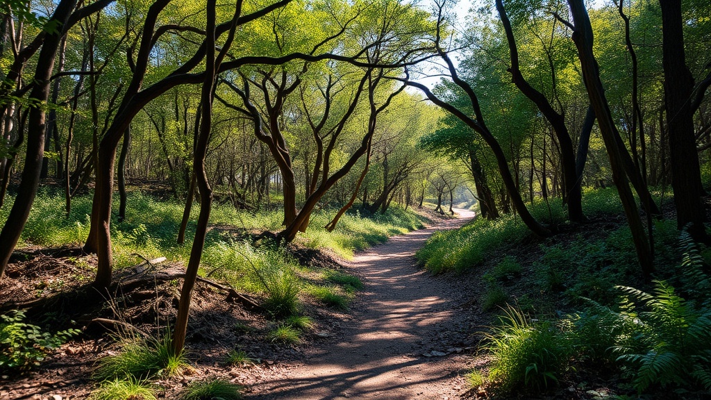
The Clifford Bernier Park Trail Network offers the most varied terrain in the area. Starting near the corner of Limebank Road and Earl Armstrong Road, these interconnected paths wind through meadows, skirt stormwater ponds, and connect to the larger Trans Canada Trail system. You'll cover about 3.5 kilometres if you walk the full loop.
What makes these trails special isn't dramatic scenery — it's accessibility. Families with strollers can manage the crushed stone sections near the playground. Trail runners gravitate toward the narrower dirt paths that branch toward the wetlands. (Watch for muddy patches after rain; they don't drain quickly back there.)
The eastern branch connects to Leitrim Wetlands — a provincially significant wetland that's home to herons, red-winged blackbirds, and the occasional snapping turtle. Bring binoculars. The viewing platform near the boardwalk gives you a clear sightline across the cattails without disturbing the habitat.
What Green Spaces Do Locals Actually Use?
Beyond the official trails, Riverside South residents have claimed smaller spaces that serve as neighbourhood anchors. Stonebridge Park — tucked behind the commercial plaza on River Road — features a loop path most visitors miss entirely. Locals walk dogs here during off-peak hours. The shade from mature oak trees (rare in newer developments) keeps the path cooler than exposed routes.
The Riverside South Community Centre grounds include a paved walking circuit that measures exactly 800 metres. It's not glamorous, but it's predictable — and that matters when you're trying to hit daily step goals or walk with elderly parents who need level surfaces. The path lights stay on until 11 PM, which beats most trail lighting in Ottawa's suburbs.
Here's how the main options compare:
| Location | Surface | Best For | Distance |
|---|---|---|---|
| Clifford Bernier Park (main loop) | Crushed stone | Families, casual walkers | 1.2 km |
| Clifford Bernier Park (wetland branch) | Natural/dirt | Birding, quiet walks | 0.8 km |
| Leitrim Wetlands boardwalk | Elevated wood | Wildlife viewing | 0.4 km |
| Stonebridge Park loop | Asphalt | Dog walking, shade | 0.6 km |
| Community Centre circuit | Paved | Evening walks, accessibility | 0.8 km |
Are There Seasonal Trails Worth Knowing About?
Yes — though Riverside South's seasonal routes require more planning than year-round paths. The Stormwater Management Pond trails (there are several, but the largest sits near the intersection of Spratt Road and Bank Street) become walkable only after the spring thaw drains and the ground firms up. Late May through October, you'll find narrow dirt paths circling the ponds that local mountain bikers have carved out. These aren't officially maintained — enter at your own risk — but they've existed for years without incident.
Winter changes the equation entirely. The Clifford Bernier paths become cross-country skiing routes when snow blankets the ground. No grooming happens — it's strictly volunteer-tracked — but the flat-to-rolling terrain suits beginners. The community centre rents skis some weekends, though inventory runs thin by February.
The catch? Parking shifts seasonally. The main Clifford Bernier lot gets plowed reliably. Trailhead access off Earl Armstrong Road becomes trickier — that informal parking area sometimes sits unplowed for days after storms.
What About Biking and Other Activities?
Riverside South connects to larger networks that expand your options significantly. The Osgoode Link Pathway — part of the City of Ottawa's multi-use pathway system — runs through the eastern edge of the community. It's paved, wide enough for side-by-side walkers, and extends south toward Manotick. Cyclists use it as a commuter route to downtown — about 22 kilometres if you follow it all the way to the Rideau Canal.
Mountain bikers have fewer official options, but the informal trail network near the Vimy Memorial Bridge offers technical features — berms, small drops, rock gardens — that skilled riders appreciate. These trails aren't sanctioned by the city. That said, they've coexisted with walkers for years through mutual accommodation. Stay alert, yield appropriately, and everyone stays happy.
Worth noting: the National Capital Commission's Capital Pathway network doesn't technically reach Riverside South yet. The gap between the current southern terminus at Leitrim Road and the community proper means you'll ride surface streets (Bank Street or Limebank Road) to make the connection. Not ideal — but the proposed Barrhaven Rail Corridor conversion would solve this, creating a direct paved link through the heart of our community.
Practical Tips for Exploring
Trail maps for Riverside South are surprisingly hard to find in one place. The city publishes individual park maps, but they don't show connections between spaces. Your best bet? Strava or AllTrails — local users have mapped most viable routes, including the unofficial ones.
Water access is limited. Bring bottles — the fountains at Clifford Bernier and the community centre shut off from October through April (freeze protection). Port-a-potties appear at Clifford Bernier during summer weekends; otherwise, plan around the community centre's public washroom hours (6 AM to 10 PM).
Mosquitoes own the wetland areas from late June through August. DEET-based repellent isn't optional if you're walking the Leitrim trails near dusk. Ticks have appeared in increasing numbers — check yourself after any off-path wandering, especially in tall grass near the pond edges.
Dogs are welcome on all trails, technically on-leash. The reality varies — you'll see off-leash dogs at Stonebridge Park and the wetland boardwalk regularly. If your dog isn't reliable around wildlife (the geese don't retreat), keep them close. The snapping turtles in Leitrim Wetlands can and will bite curious noses.
The Spots Nobody Talks About
Every community has its overlooked corners. In Riverside South, that distinction belongs to the undeveloped hydro corridor running parallel to Spratt Road. No official trail exists — just a mown grass path beneath the transmission lines that locals have worn in over years. It connects no destinations worth naming. The view isn't special. Yet on summer evenings, you'll find residents walking slowly beneath the buzzing wires, appreciating the open sky and the absence of traffic noise.
There's also the small stand of mature cedar trees behind the commercial development at Cornerstone Boulevard — maybe fifty metres of actual forest in a sea of suburban infrastructure. A narrow path threads through it. Children play there. Adults walk through quickly, as if embarrassed to be found enjoying something so modest.
These spaces matter because they belong to us — not to visitors, not to the city, not to developers. They're Riverside South's small resistances against becoming just another interchangeable suburb. You won't find them promoted. You'll just have to walk until you stumble across them, then return until they feel like yours.